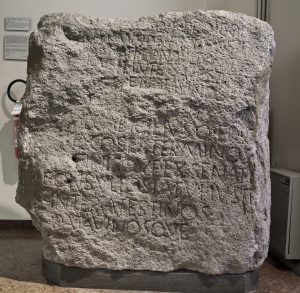
The boundary markers
The first traces of the Roman presence in the territory of Este were the construction of Lepidus’ road in 175 B.C., which connected Bologna and Aquileia via Este, and the senate’s measures to fix the boundaries between the territories of Este, Padua and Vicenza. The regulation of the boundary between Este and Padua is documented by three boundary stones found in Teolo, on Monte Venda and in Galzignano-the latter exhibited here-dating back to 141 B.C., when proconsul Lucius Caecilius ordered by decree of the senate that the boundaries between the two cities be established with demarcation stones in particularly strategic places for the control of the Euganean thermal waters. In 135 B.C. the same measure was taken by proconsul Sextus Attilius Serrano for the borders between Este and Vicenza with the Lobia cippus (Maffeian Museum in Verona).